Where, on the Oceans of the World, is the point furthest away from any land? Sometimes lightheartedly called "the point of the longest swim", the most frequently used term for such points (for instance - where, on some island, is the point that a bird wold have to fly furthest to reach the sea) - is the "Pole of Inaccessibility"). There may be many such poles depending on the nature of the problem being proposed (longest swim, longest flight, longest cross-land trek etc.)
Some thirty years ago, a simple web page was published on the location of such point, found to be in the wast emptiness of South Pacific. The computation required to find it's exact location was performed as a small demonstration of the computational capabilities of a software product called "Hipparchus Software Library", at the time the property of a business of which the only thing surviving to this day is an archival web page. This publication was recently joined by an updated version.
It came as a great surprise to the author that what was not meant to be more than a marketing geographical curio snippet (named "Point Nemo") would attract the attention of the general Internet public to the extent that it did.
Surprisingly, in all the years since, nobody approached the author (who happens to reside on its coast) with the question: what would be the location of an equivalent point on the Adriatic Sea? A quick glance at a chart reveals that the Adriatic Sea is connected with the Mediterranean by the relatively narrow Strait of Otranto, and that such a point must obviously lie somewhere near the centre of the South Adriatic Basin.
But where exactly?
It might appear that computing the precise location of the point in a relatively small body of water such as the Adriatic sea is, would be much simpler than performing similar calculation on the millions of coastline point coordinates in the vastness of South Pacific.
Surprisingly, it is the exact opposite. "Roundness" of both the East (Croatian, Monte Negro and Albanian) and West (Italian) coasts in the southern Adriatic means that the influence of small inaccuracies in the coastline representation - as well as inevitable uncertainty in the physical features defining the "coastline" (especially if calculating with millimetric precision) will have a great deal of influence on the final result.
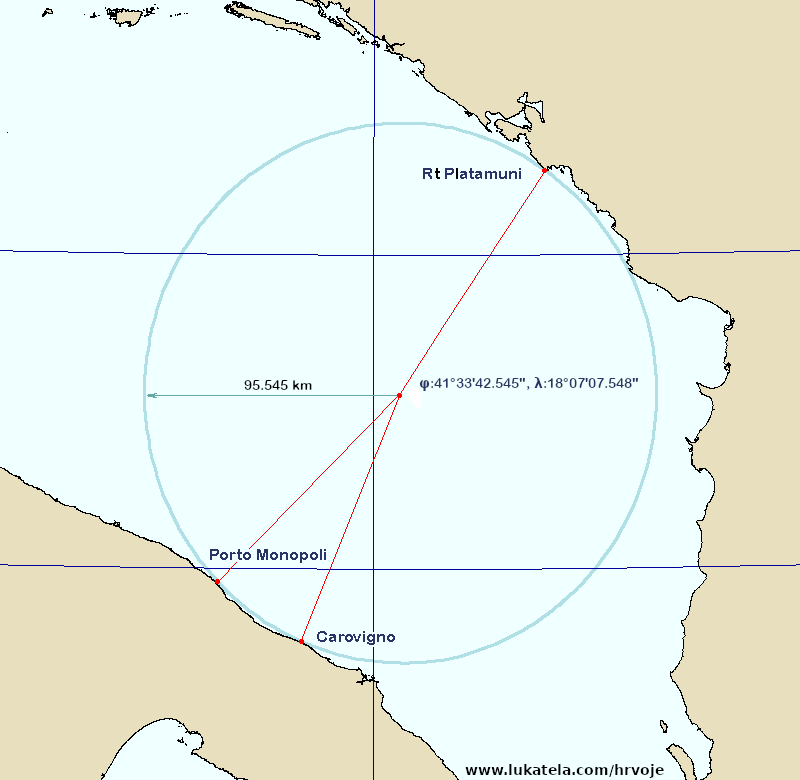
Performing the calculation using the same data as was used in the second of computations mentioned above (Open Street Map data, cf.: "...Nemo Revisited...") yields the following set of coordinates:
The point furthest away from any land:
41°33'42.545" 18°07'07.548"
Three closest points on the coastlne:
42°16'07.195" 18°46'30.425" Cape Platamuni (Monte Negro)
40°57'22.196" 17°18'32.612" Porto Monopoli (Italy)
40°46'05.582" 17°40'45.031" Carovigno (Italy)
The three points on the coast are all exactly 95544.548 meters
(95.545 km) distant from the Adriatic Point Nemo. All the coordinates are
northerly latitude (φ) and easterly longitude (λ). Points on the cost are
named by the geographical features they are close to. The latitudes and
longitudes expressed in decimal degrees are as follows:
41.56181813, 18.11876337
42.2686654, 18.7751181
40.9561656, 17.3090589
40.7682171, 17.6791752
The computation can be represented by a simplified chart, as follows:
It may also be interesting to inspect the locale of three coastal points (for instance, at maps.google.com):
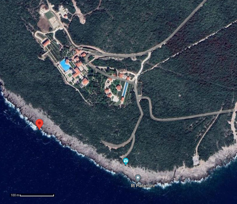
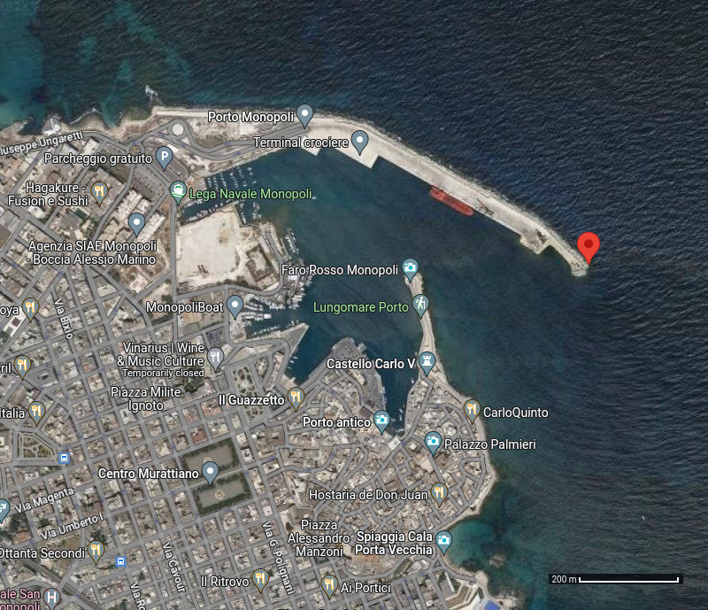
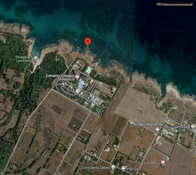
Unlike the computational exercise described in the introduction to this publication, all three coastal points ("proximity vertices" in computational lingo) are readily accessible. Here is the challenge to those reading this page: visit all three points and determine the coordinates of the points indicated on the photographs using a simple GPS device that is capable of recording the average of coordinates sampled over a period of time (an hour or two is usually quite sufficient).
Using the coordinates so measured, the computation can be repeated using a free, readily available software library published by the author of the page. Will this change the location of the far point, and if so, by how much?
It is also possible that another set of proximity vertices might be identified: the coastline source data used to perform the calculation presented above comes with no guarantee of accuracy or completeness. If the equal distance from those three points is greater than the number presented above, and if there is no other coastal point closer to it than that distance, our knowledge of the exact location of "Adriatic Point Nemo" would indeed be improved.
The content is published under Creative Commons ByNcNd license.
Author: [Hrvoje Lukatela]